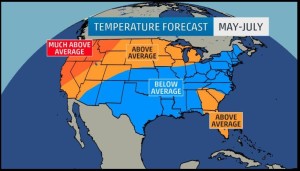
The weather is changing from a ever moving and quick jet stream, to a long term two month stationary front that promises a warmer drier spring for most of the nation. When we look at past recent trends, the last 360 months have been warmer, and with more of a pattern on longevity. We have created a role in our world that keeps us global and mobile. At this time in human history, our weather is truly evolving into a stationary pattern of two month weather, that sticks and stays, warmer and drier, for the most part.
Warmer and Drier Becomes the Status Quo
 Keeping with the pattern review, the most recent year has created a two month static flow, with constant weather for 8 weeks, over the last year. From 2013-2015, the winter of 2014 was cold and wet, from Dec-Jan, and then Wet and Warmer, from Feb to March 2014, with a drier and colder April/May 2014, wet and cold May/June 2014, Hot and Dry August/September 2014, Colder and Dry Oct/November 2014, with Warmer and Drier Dec/Jan 2014/2015, and then a mix of a change. The beginning of January 2015 was unseasonably Warmer and Drier for most of the country. January 19, 2015 was above freezing for most of the midwest, and was a day of a mark for warmer and drier to change to Colder and Drier. This resulted in 7 weeks of below freeze temperatures, even for high temperatures. Except for the Upper East Coast, the country was cold, but dry. The Week of March 9, 2015, saw a change to Warmer and Drier, with a swing of the jet stream for only two days on March 18 & 19th. The period should stay warmer and drier to the second week of May, with a new transition, based on current trends, to match a dry and warm period of time.
Warmer and Drier should Stay the Norm
With the advent of this lack in the swing of the jet stream, winds are light, and often a pattern of intense afternoon sun. Morning is often cloudy, with breaks in the clouds, but no precipitation. The constant of the weather has been dreary, but it has resulted in record breaking snow, and heat in parts of the coasts. The main thing that has changed over the last couple of months, is the relative warmer and drier pattern. With the lack of the change to the jet stream, the storms do not produce themselves, and precipitation is minimal. The country is going to see more of this pattern, with many people expecting cooler patterns in the south and east, and warmer and hotter out west, in the mid west, and near the Florida Panhandle.
Warmer and Drier will move to the Northeast In Summer
With current trends in thought, there should be many steps towards a warmer and drier weather pattern for the northeast part of the US. With this change, there could be a continuation of the same for the mid west, or a very rainy period in the August to September months. We will have to see how warmer and drier vs. colder and rainy in fact comes to our weather patterns in the days ahead.
